1
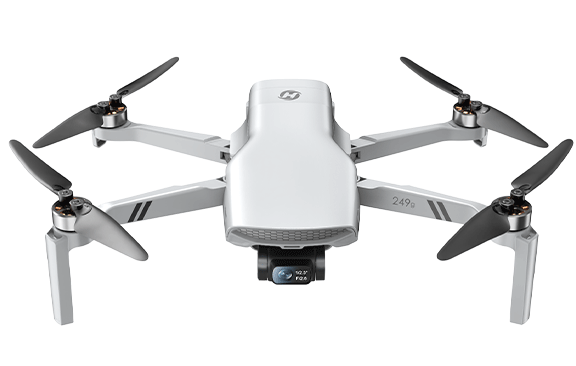
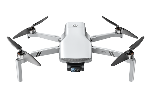
DRONE
Model: HS360D
Weight: 249 g / 8.78 oz
Max Flight Time: 40 minutes (per battery, in a windless environment)
Max Flight Speed: 7 m/s
Max Flight Height: 394 ft / 120 m
Max Takeoff Altitude: 9842 ft / 3000 m
Max Wind Speed Resistance: 5.5 m/s
Operating Temperature Range: 32° to 104°F (0° to 40°C)
Size: 140 × 90 × 55 mm (Folded)
210 × 180 × 55 mm (Unfolded)
DRONE BATTERY
Model: DSB54085-2S
Capacity: 2500 mAh
Voltage: 7.4 V
Max Charging Voltage: 8.9 V
Battery Type: Lithium-ion Polymer Battery
Rated Power: 18.5 Wh
Charging Temperature Range: 41° to 104°F (5° to 40°C)
Charging Time: about 3 hours
USB CHARGING CABLE
Input: 5V / 3A
Rated Power: ≤15 W
TRANSMITTER
Operating Frequency: 5745–5825 MHz
Max Flight Distance: 19685 ft / 6000 m (outdoor and unobstructed)
Usage Time: about 2.5 hours
Charging Time: about 110 minutes
Battery Type: 7.4 V 1100 mAh Lithium-ion Polymer Battery
Operating Temperature Range: 32° to 104°F (0° to 40°C)
CAMERA
Operating Frequency: 5745–5825 MHz
Max Transmission Distance: 19685 ft / 6000 m (outdoor and unobstructed)
Max Photo Resolution: 4000 × 3000 P (in TF card) / 3840 × 2160 P (in mobile phone)
Max Video Resolution: 3840 × 2160 P @20 fps (in TF card) / 1280 × 720 P @30 fps (in mobile phone)
Controllable Range: -90° to 0°
Photo Formats: JPEG
Video Formats: MP4
Supported TF Cards: Class 10 or above, up to 256 GB
Supported File Systems: FAT32
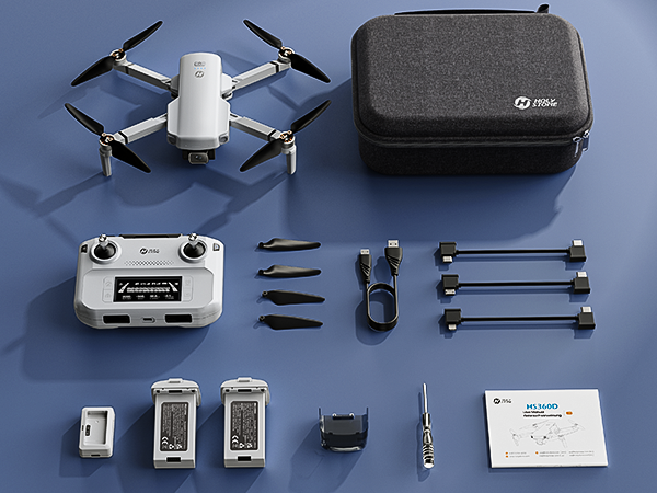
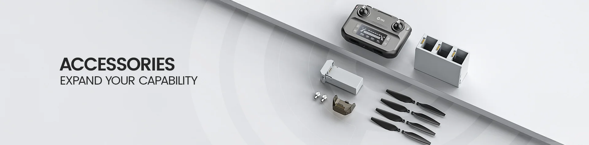
Dual Battery Version HS360D Drone × 1 Remote Controller × 1 Drone Batteries × 2 Charger × 1 Spare Propellers × 4 Screwdriver × 1 Camera Protector × 1 Charging Cable × 1 Type-C Cables × 3 Portable Carrying Case × 1 User Manual × 1 |
Motors won’t start — what should I check?
- Sticks not in the correct unlock position.
Push both joysticks to the inner–lower corners to unlock.
- Compass not calibrated / abnormal status.
Calibrate the compass before flight until the TX beeps and status is normal.
- GPS not ready for GPS mode.
Wait for solid GPS (outdoors). If flying indoors, long-press the GPS key to enter Attitude (ATTI) Mode.
- Low battery.
Recharge/replace the battery if the drone LED shows continuous red.
Why can’t I adjust the gimbal?
- Camera/gimbal cover still on.
Remove the cover before powering on.
- Drone not on a level surface during init.
Place it flat and wait for gimbal initialization.
- In compass calibration.
Finish calibration; the gimbal doesn’t work during it.
- Obstruction under the gimbal.
Ensure clearance or use a landing pad.
The drone drifts or flies unstably — why?
- Weak GPS (near buildings/trees/obstructions).
Fly outdoors in open areas with strong GPS.
- Compass interference (metal, lines, towers).
Land and recalibrate away from interference.
- Damaged/incorrect propellers.
Replace or reinstall props and check tightness.
- IMU not calibrated.
Calibrate the IMU per the manual before flight.
Video is laggy / range is short — what helps?
- Signal interference (buildings, Wi-Fi, towers).
Choose open areas; keep antennas facing the drone.
- Phone performance / background apps.
Close other apps; ensure your phone meets app requirements.
- Abrupt stick inputs.
Use smooth stick motions to keep the link stable.
Battery won’t charge / power the drone?
- Battery not seated in hub or aircraft.
Insert until it clicks and LEDs behave normally.
- Damaged charger/cable or wrong adapter.
Use the original Type-C cable and 5V/3A adapter.
- Temperature out of range.
Charge at 5–40 °C (41–104 °F). Full charge ≈ 3 h per flight battery.
How do I pair and see the live feed?
- Power on drone (level surface), then TX (short press + hold 3 s).
Wait ~40 s; TX long-beeps when paired.
- Connect phone to TX via the included cable.
On Android, choose “Charge only” if prompted. Open HS FLY app to view live feed.
What TF card is supported and what’s recorded?
- Supports Class 10 (or above) TF cards up to 256 GB.
Insert the card before powering on for up to 4K photo (4000×3000) and 4K@20fps video to card.
- Phone recording is lower resolution.
4K to TF card; up to 1280×720@30fps to phone.
How does Return-to-Home (RTH) work?
- Smart RTH (manual).
Short-press the RTH key; the drone returns to the recorded Home Point at the set Return Altitude (RA).
- Failsafe RTH (auto).
Triggers on signal loss (with GPS & Home Point). Control is restored if link reconnects; press RTH to exit.
- Low-Voltage RTH (auto).
Stage 1: return & hover in a safety zone (≈98 ft radius/66 ft height). Stage 2: auto-land when critically low.
Obstacle avoidance is not available during RTH — fly in open areas.
What are the Beginner Mode limits?
- Default caps for new users.
Distance ≤ 98 ft (30 m), Altitude ≤ 98 ft (30 m), RTH Altitude 66 ft (20 m).
- Need custom limits?
Turn off Beginner Mode in HS FLY > Settings, then set distance/altitude/RA as needed.
Can I fly indoors?
- Yes, in ATTI with Optical Flow.
Long-press GPS key to enter ATTI. Optical-flow works best at 1.6–9.8 ft; avoid dark/reflective/textureless floors.
Precision is affected by lighting and surface texture—proceed carefully.
How to use Emergency Stop?
- For emergencies near the ground.
Hold the Emergency key for 2 s below 16 ft altitude to cut motors. Use only to avoid danger.
What flight speeds and camera tilt are available?
- Speed modes.
Camera 3 m/s (Low), Normal 5 m/s (Mid), Sport 7 m/s (High). Short-press Speed to switch.
- Gimbal tilt.
Dial to adjust −90° to 0°.
Any tips for GPS Follow, POI, Catapult, Ascension, Spiral Up, TapFly?
- Use outdoors, strong GPS, clear surroundings.
Respect minimum distances (e.g., ≥7 ft from subject for Catapult/Ascension; ≈16 ft for Spiral Up) and note follow limit ≤164 ft.
- No obstacle avoidance.
Monitor the path and be ready to exit via the right stick or tapping the mode icon.
- For TapFly.
Pre-load the map on Wi-Fi/Cellular, then plot ≤16 points and tap GO.
How long to charge and how long can it fly?
- Flight battery: about 3 h to full; up to ~40 min per battery (no wind).
Use 5V/3A adapter and the original cable via the charging hub.
- Transmitter: about 110 min to full; ~2.5 h usage.
You cannot power on the transmitter while charging.

 Sign in
 Sign up